
Residual Layer Ozone Study
Vertical Mixing, Advection, and Photochemical Produciton of Ozone in the Southern San Joaquin Valley
Project Summary
The San Joaquin Valley (SJV) has become the locus of one of the more vexing air quality challenges in the nation, and consequently is classified as an extreme ozone nonattainment area for the 8-hour ozone NAAQS. One of the difficulties of fully understanding the causes of degraded air quality of the SJV is its long and deep geography, running approximately 400 km (Stockton to Arvin) to the south-southeast, spanning an average of ~100 km across, and bordered by a rim that rises to over 3 km on its eastern flank and ~1 km to its west. Because of the topographic isolation of the SJV, air quality along its surface is strongly dependent on the exact nature of the mixing aloft, as the air that naturally feeds into it from the gap in the Pacific Coast Range around the San Francisco Bay Area stagnates as it approaches the cul-de-sac of the Southern SJV (SSJV) and the Tehachapi Mountains. Attaining air quality standards in the SSJV thus requires a much better understanding of the dynamical influences on the vertical mixing at the top of the boundary layer.
This airborne project will collect data throughout the diurnal cycle in the SSJV including horizontal winds, humidity, temperature, ozone (O3), nitrogen dioxide (NO2), methane (CH4), and ethane (C2H6), all at 2-second (~125 m in the horizontal, 5 m in the vertical) resolution or better. This very unique data set will provide unprecedented observational constraints to support high precision modeling of ozone concentrations and its spatial distribution pattern throughout the region. Furthermore, the experiment is designed to allow for an explicit empirical estimation of the vertical mixing of ozone between the residual layer aloft and the shallow boundary layer overnight in the presence of the region's low level nocturnal wind maximum, and during the morning hours when the mixed layer grows up rapidly through the residual layer. Moreover, the budgeting techniques used with the data set can quantify the midday photochemical production of ozone for comparison with a full chemistry air quality model. In this way the experiment is optimized to constrain modeling efforts across the entire diurnal ozone cycle, and provides a detailed paradigm with which to improve air quality modeling efforts. By measuring the explicit terms of the ozone budget equation this experiment can test specific model components (both transport and photochemistry) and definitively quantify the ultimate contribution of residual layer O3 to the following day's afternoon maximum.
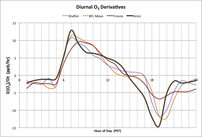
The figure above shows the average time derivative of ozone measured at 5 CARB air quality monitoring stations spanning a transect from upwind to downwind across Bakersfield, CA during June-September of 2012. These data show the large burst of ozone that appears in the mid-morning during the rapid growth of the convective boundary layer which mixes with the residual layer (sometimes called "fumigation"), and that it has made the majority of its contributions to surface ozone by about 09:00 Pacific Standard Time (PST). Then in the afternoon the photochemical ozone production dominates, followed by strong titration with fresh NOx emissions once the sun goes down. This project will investigate the ozone budget (as well as those of other scalars) throughout the diurnal cycle to better quantify the effects of mixing to the overall daily build up of ozone.


 Home | Research | People | References | Links | Future Work